|
| |
 Sutton Valence in Kent lies on the old A274 Tenterden to Maidstone road,
between Headcorn and Maidstone . The village lies on the top of
the hills overlooking the flat lands towards Staplehurst and
Headcorn . Sutton Valence in Kent lies on the old A274 Tenterden to Maidstone road,
between Headcorn and Maidstone . The village lies on the top of
the hills overlooking the flat lands towards Staplehurst and
Headcorn .
The earliest remains found in the village are a Roman road,
possibly the one running to Beauport near Battle . Roman
cemetery has also been found nearby, which could mean this
was a staging post lying on the edge of the forest of Anderida.
Local legend believes that on the playing field which is known
as bloody mountain was a Saxon Battle field, but no concrete
evidence has been found .
The village is recorded in the Domesday Book , before 1066 it
was owned by Leofwine Godwin (Half brother of King Harold),
and after the conquest was granted to Odo bishop of Bayeux .
The village consisted of a large meadow and mill and a wood
which supported 50 swine.
During the reign of King Henry III in 1254 the village was granted the
right to hold a three-day market, which became one of the county's
largest cattle markets carrying on till the 1800's.
Originally known as Sutton , then Town Sutton , in 1265 the land
and the small castle was seized from Simon de Montfort after his
defeat at Evesham and given to William de Valence (The ruins of
the castle are now looked after by English Heritage). Because of
William's patronage the name was changed to Sutton Valence
possibly via Sutton de Valence .
The village was involved in the Broadcloth industry , which was
introduced into Kent by Edward III in 1331 . He made illegal the
export of unwashed wool from England and encouraged weavers from
Flanders to settle in the area. In 1531 William Lambe became
master of the Clothworkers Company in London, and became an
advisor to Henry VII , the church received his patronage, and
a chapel dedicated to him was created. In 1576 he founded the
Sutton Valence free Grammar School which has grown from its
original 20 boys to about 400 boys and girls. |
|
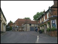
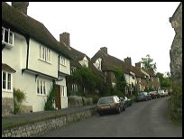
 The centre of Sutton Valence in Kent is a very pretty place, but the
roads are narrow, and care must be taken both in the village
and turning across the main road, as the junction is on a corner. The centre of Sutton Valence in Kent is a very pretty place, but the
roads are narrow, and care must be taken both in the village
and turning across the main road, as the junction is on a corner.
The views from much of the village and church are stunning, and
on a clear day hills as far south as Brightling in Sussex can
be seen. |
|
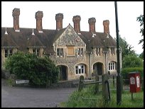
 The main A274 passes through a corner of the village, which leaves
the village centre untouched, although the church is on the opposite
side of this busy route. The main A274 passes through a corner of the village, which leaves
the village centre untouched, although the church is on the opposite
side of this busy route.
There are a few local shops and public houses, but the main
shopping centre is in Maidstone , about 3 miles north.
The nearest train service runs into Maidstone , providing links
to London and the Kent coast, however the easiest to get to is Headcorn,
which gives an excellent service to London and Dover. |
|
| Sutton Valence is shown as the red symbol on the map. |
|
|
Nearby Villages
(click on symbol to see the village page) |
| Village= | |
Town= | |
Recorded in Domesday= |  |
| |
|
|
Boughton Monchelsea |
(Miraculous vision) | | 3.07 miles |
|
|
Coxheath |
(Soldiers and Duels) | | 4.59 miles |
|
|
Headcorn |
(King Johns Oak) | | 3.23 miles |
|
|
Linton |
(Cavalier loses House) | | 3.75 miles |
|
|
Marden |
(Broadcloth and Agriculture) | | 5.32 miles |
|
|
Staplehurst |
(Charles Dickens train crash) | | 3.97 miles |
|
|


